Heart in the waterfall at Midnight Hole in the GSMNP

Swimming at Big Creek in the Great Smoky Mountains National Park

Best  Swimming Hole Ever

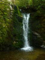
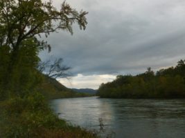
Jumping in a creek in summer is one of the most refreshing experiences the Southern Appalachians have to offer. For swimming in summer, we love to have a nice dipping hole with places from which to jump.  One of our favorites is Big Creek.

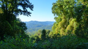
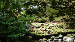
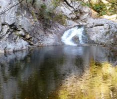
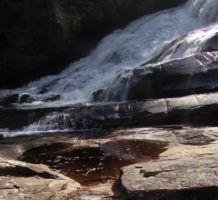
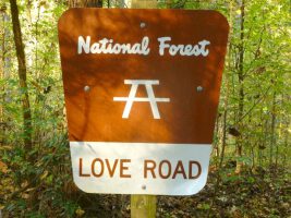
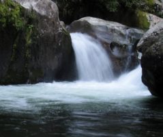
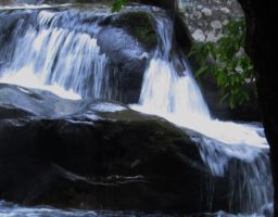
This  is a pristine creek that rushes down the mountain in the GSMNP.  Our favorite spot on the creek is  Midnight Hole.  Just past this is Mouse Creek Falls which is also quite beautiful.   The hike up to this special spot is fairly short and easy.  It is about 1.5 miles and begins in the  parking lot of the Big Creek Campground  which is on the exit 451 on I-40 just over the border in Tennessee.

Directions

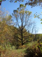
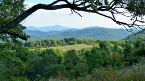
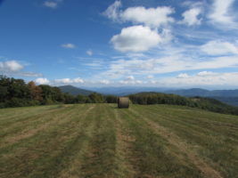
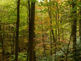
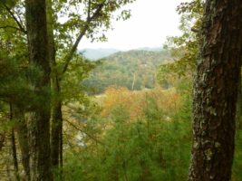
From our cabins there are a couple of ways you can travel to this magical place.  If you have a truck or 4 wheel drive you can go on the dirt roads up and over the mountain.  But, I do not suggest this route if you have a car without much clearance.  The road can get washed out and it can be pretty bumpy and challenging.  However, if you don’t mind going slow and taking your time, it’s a great way to see wildlife.  There is an elk herd along the way and they are pretty easy to spot.  We have also seen bear driving this way.  The other ways you can go are either through Waynesville for through Newport, Tenn.

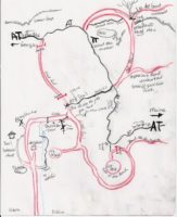
To go the rugged way, take Roaring Fork and turn right on Meadowfork road.  Go about  1.5 miles and you will see a brown sign that says Max Patch.  Turn right onto Little Creek Road.  Go to where the pavement ends.  We advise you to turn right on Poplar Gap loop road as this is paved.  It’s very windy, so go slow.   When you come to a stop sight you will be back to Little Creek Road,  turn right.  Go until you come to a T intersection and turn left.  There are no signs on this road.  (Max Patch would be to the right).   After you turn left,  take the first right toward Harmon’s Den.   This road will take you to I-40.  Take  I-40 west to Exit 451 and go to the Big Creek Campground.   The trail head is across the road from the bath house.

Swimming Midnight Hole at Big Creek in the Great Smoky Mountain National Park

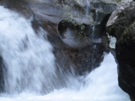
Can you see the heart?

Swimming Big Creek in the Great Smoky Mountain National Park

Here is a short video from swimming at Big Creek today.

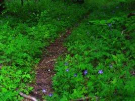
Swimming can happen in many spots along the trail.
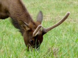
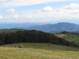
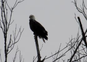
Elk herd at Harmon Den

Elk Herd

The elk hang out between the Harmon Den horse camp and the Harmon Den parking area.  There is a beaver pond they like to play in and some fields where they like to graze.   They are not hunted, so they are very calm and easy to observe.  But, they are very large, so do be careful and keep your distance.


Dancing Sun Cabins Hiking Map

Hiking and Hiker Support for the Appalachian Trail

Dancing Sun Cabin National Forest MapDancing Sun Cabins is a great place support thru hikers or to even join someone on a hike along the Appalachian Trail.

Our property sits at the base of Max Patch Mountain and Walnut Mountain. Our creeks drain both of these watersheds. It is a short drive to the Max Patch parking lot from our cabins or to the Gorenflo Gap parking lot. Both access points make it easy to access the trail by car. It is very easy to meet a hiker at Max Patch or Harmon’s Den and join the hike.

You can hike up to Lemon Gap or Walnut Mountain Shelter on a 1-2 hour hike from your cabin door. You can even hike up to Max Patch from our cabins with a little help with directions from Tom and Rebecca. The hike takes us a few hours to go up and back and is a little steep, but well worth it.

We love to do “trail magic” from time to time, so let us know if you are supporting a hiker and we may go up and feed them breakfast.

Hike From Your Cabin Door

From a “wander and ponder” stroll through the forest to steeper challenges that offer wonderful cardiac workouts, we have just the hike for you right out your front door.

Each cabin has a book with maps to help you find the perfect hike. Rebecca and Tom can also suggest hikes specific for the weather conditions and your needs.

There are many, many choices.

Hiking is spectacular any time of year.  Here is a video from our Autumn Hikes.

The Waterfall Trail:  Wander up the driveway and take right past the Appalachian Shack to the waterfall trail. We are so fortunate to have the National Forest for our backyard. Come and play. The waterfall offers a great opportunity to play in the creek on a hot summer’s day. Explore the cascades and waterfalls either in the creek or on the trail that winds in, out and around the forest.

The Labyrinth Trail:  There is only one spot on our 100 plus acres that you cannot hear our waterfall. This little Hollow tends to be silent, even on windy days, when the wind roars through the tree tops. This is the place we chose to build our Labyrinth. A Labyrinth is not a maze. It is a meditative walk with only one path through it. It is an ancient design. It is used for prayer and deep meditation. We welcome you to come and walk our Labyrinth in the woods. It is a short walk from your cabin door.

Loop to Cat Pen and T and R Bald: This is a 2-3 hour loop that we have created from our property that incorporates the Appalachian Trail. It is a delightful walk up to 2 bald areas that offer incredible views. Cat Pen is at the top and allows one a 360 degree view with an incredible view of Max Patch and Lemon Gap as well as Bluff Mountain.

Loop to Walnut Mountain: Another wonderful loop that incorporates the Appalachian Trail is our Walnut Mountain Loop. This takes 2-3 hours also and can be joined with the Loop to Cat Pen to make a nice full afternoon or day hike. This loop takes you to Walnut Mountain AT shelter. Here it is possible to go even further to Lemon Gap and then loop back to your cabin. The possibilities are endless as are the views.

Historical Wasp and Wolf Creek Falls: This is a challenging 10 mile hike that begins at the back of our house. It takes you through an old community that died out in the 1930’s. You walk across Kale Gap and down, down, down to the waterfall then back. This hike gives you a sense of what life must have been like to former generations. It is a full day hike and really for experience hikers. There are several opportunities to take the wrong path or road, so pay attention to the directions and always know how to come back.


Please join us in prayerful support of our Veterans as they “Walk off the War” by walking the entire Appalachian Trail.  We support Warrior Expeditions.

Walnut Mountain

Walnut mountain is the mountain we live on. You can access it right from your cabin door. It is full of Appalachian delights. There are many springs that run off this mountain and feed our waterfall. It is not unusual to see water just bubbling up from the ground. To us, nothing is more precious than this clear, fresh water.
We feel we are stewards of this land and we are blessed to live here. We love sharing this with others.

Our house sits 0.5 miles from the cabins. There is an old forest road that leads up behind our house and continues on to the to a place called Kale Gap. This is the route that families took for many years to connect the Roaring Fork community with the WASP community which was located on the other side.

On one side of this gap is Walnut mountain, on the other is Bluff mountain. The Appalachian Trail crosses here. There are many loops you can make with the AT and the forest road to give you some beautiful day hikes.

I have included some pictures of this mountain. To the South of Kale gap is Lemon Gap and Max Patch. To the North is Bluff Mountain and then on to Hot Springs. There is a nice bald to the north called Cat Pens.

The hiking possibilities are endless. Tom and I really enjoy just wandering through the woods here. It is a very special place.


Hiking from your cabin door Autumn Hiking

Walnut Mountain

Poke Berries

Walking up Walnut Mountain

Hiking is endless at Dancing Sun Cabins

Hiking Tips

Here are some things to think about when hiking in our woods.

Max Patch hiking is the best
Max Patch is one of our favorite places to hike
  • Take a map along. We have provided maps for you to carry with you that will help you find your way in our forest and connect to the Appalachian Trail.
  • We take a Garmen GPS unit with us, but we ALWAYS compare it to our maps. GPS can get you lost around here and it rarely gives you a good idea about how long a trail might be.
  • The blazes for the AT are white. When you see 2 blazes, that means to pay attention as there is another trail crossing the AT.
  • In the summer, the understory gets thick with stinging nettles, poison ivy and blackberry vines. Come prepared for this, or plan to hike on trails that are heavily traveled.
  • We do have snakes here. Most are not poisonous. Rattle snakes make a pretty loud sound. Copperheads are shy and prefer not to be bothered. These are the only two kinds of snakes that are poisonous here. It is best just to leave them alone. If you should experience a snake bite, just stay calm and get to help. Slow breathing and keeping your heart rate low is the best treatment.
  • Yellow jackets can be ferocious if disturbed. Please be aware that they live in holes in the ground. It is best not to poke holes in the ground. If they come after you….RUN!!!! Run away from their nest and try to get them off of you. They can sting more than once. Jewel weed takes the sting away.
  • It is good to carry 50 mg of Benadryl and 150 mg of Zantac with you just in case you experience and allergic reaction.

Here is a link to little video on helpful and harmful plants you may encounter along the way.

Lemon Gap Hiking on AT

Hiking at Lemon Gap on the AT

Lemon Gap offers a nice spot to park your car along the AT in order to section hike. It is located between Max Patch and Walnut Mountain Shelter.
Lemon Gap Access Point on the Appalachian Trail is a bit remote. It is past Max Patch on a dirt road. Max Patch Road becomes Tenn. 107 after you cross the state line. The beauty of the remoteness makes it worth the drive.

From Max Patch to Lemon Gap 6.2 miles
The hike from Max Patch to Lemon Gap is mostly down hill and the walk is nice and gradual The hike to Max Patch is a little up hill , but surprisingly easy as the climb is gradual. There is a shelter between Lemon Gap and Max patch.

Lemon Gap to Bluff Mountain 3.7 miles
This is the easiest way to hike to Bluff Mountain whose elevation is just short of that of Max Patch. With a little over 1000 ft in elevation change, this makes for a good work out. You will come to Walnut Mountain Shelter (1.3 miles) before you get to Bluff Mountain. As you begin to climb up Bluff Mountain, you will see a camp site to the right and a trail leading to a big fields with a cross roads. Head out directly across from the camp site and follow the road up to a beautiful bald area known as Cat Pens.This is a beautiful bald that is similar to Max Patch only smaller. On a nice clear day, you can see Max Patch from this vantage point.
Bluff Mountain is where you will experience most of the elevation gain. You will hike up, up and up some more. But the view from the top is beautiful when the leaves are down. There is no bald up here but there are nice outcroppings.

Lemon Gap to Garenflo Gap 7.4 miles

If you continue on from the hike described above, you will descend from Bluff Mountain to Garenflo (AKA Gorenflo) Gap. This Gap offers a beautiful Rock that sits in the path of the rising and setting sun. This is a very nice hike and is a great work out as it takes you over Bluff Mountain.

Driving Directions: GPS location: N35° 49.30’ W082° 56.16’

From Dancing Sun Cabins
Go down Roaring Fork Road to Meadow Fork Road (State Road 1175). Turn right on Meadow fork and go a couple of miles until you see a brown sign directing you to Max Patch. Turn right on to Little Creek Road (State Road 1181). Follow Little Creek Road (1181) which will turn into a gravel road for 3.5 miles to a T intersection which is Max Patch Road (State Road 1182). Turn right onto Max Patch Road (gravel) and go for 1.6 miles to Max Patch parking and continue past Max Patch parking on a gravel road for 3.6 miles to the Lemon Gap parking access. This road becomes Tenn 107 when you cross the Tenn line.

Hiking the Trail:

North to Garenflo Gap (7.4 miles), go the direction of the white blaze on the post on the left side of the parking lot.
South to Max Patch (6.2 miles), go the direction of the white blaze on the tree on the right side of the parking lot.

Hike to Lemon Gap from Max Patch

Fields at Max Patch after they mow

Appalachian Trail blazes are white

Light in the Pisgah National Forest

Rankin Bottoms: A great place for bird watching

One of our favorite places to visit in the winter is Rankin Bottoms.

This unique wildlife area is located where the Nolichucky and French Broad rivers meet and enter Douglas Lake. This is a flood plane area.

The water level is managed by the TVA. The water level is dropped very low in the winter leaving mud flats and watering holes that are perfect areas for birds to gather. This high altitude swamp has unusual features such as Osage orange trees, Cyprus trees, and Honey Locusts.

This is often a warm sunny spot in the winter and a great place to see large birds such as Egrets and Herons. Geese,Sandpipers, Gulls and many other birds find this the perfect spot to feed. Check out what the Tennessee Ornithological Society has to say about this place. It’s incredible!

The landscape has unique plant life that create surreal colors and scenery. We find it a great place to wander.

​To reach Rankin Bottoms, you must travel to Newport, Tennessee. We advise going to Hot Springs and following 25/70. The road is not really closed even though the bridge is out. You can take Fugate Road, just go slow as the locals do. When you get to the end of Fugate, turn right on Hwy 107 and cross the bridge. Turn left toward Newport on 25/70.
Go through downtown Newport and bare right on Industrial Road. Stay on Industrial Road about 5 miles you will have to turn left to remain on Industrial road, the go another 5 miles until you reach Rankin Hill Road. There will be a Wildlife refuge sign here. The road follows the railroad tracks and is a little rough in places, though you do not have to have 4 wheel drive unless it is muddy.

Wolf Creek Falls excellent swim

Wasp and Wolf Creek Falls

Wolf Creek Falls

There is an easy way and a harder way.

First the easy way.

Wear shoes that you can get in the water with.  There is wading involved.

Drive to Hot Springs and turn left at Sara Jo’s gas station onto 25/70.   Go about 1.5 miles to Upper Shut-in road and turn left.  Go to the end of the road, it will turn to dirt and there may be a sign that says road closed.  That is ok.  Just go to the end where the forest service gate is usually closed.   You can park there without blocking the gate.

Hike beyond the gate and in about 1/2 mile you will come to a T intersection.  Turn left here and go until you come to the creek.  There is a construction site there for a new bridge.

Make your to the other side of the creek and turn right to follow the creek down to the waterfall.   You will come to a camping area.  Look for a small trail at the end of the camping area that is unmarked, to make your way down to the fall.  It is not a difficult trail.

T & R Rating
Excellent Hike! Excellent Swim!
Difficult
2000 ft total elevation
5 miles in and 5 miles out
10 miles total
Short areas of steep climbing, otherwise climb is gradual.

This favorite swim holes and hiking experiences is Wolf Creek Falls.  This is one of the most beautiful waterfalls around and is accessible for a swim.   We suggest you pack a lunch and head out with plenty of water.  We often stash a bottle of water along the way for the return trip home.

This hike begins right behind our house and goes up to the forest roads and AT as the others do.  It’s a tough hike, but it rewards you with a wonderful swimming experience is the clear waters of Wolf Creek.

So, head out behind the house and go up and through the fields. After about a mile you will come to a “T” intersection with a forest road. Turn left and go less than 1/4 mile and turn right onto an ATV trail. (If you get to the gate on the forest road you have gone to far)

Go up the ATV trail. This is a short steep climb (the steepest you will encounter on this trail)

In less than 1/4 mile you will reach the AT.  This is Kale Gap. Go straight across on an old road.  Continue on this road and you will come to a “Y” in less than 1/4 mile. Go to the right at this Y intersection and travel down.  You will walk over a mile down and eventually you will come to a “T” intersection with another old road.  DO NOT TURN LEFT here, but go right.  In less than 1/2 mile the road will come to a subtle “Y”.  You will go left here.  There are huge rocks on both sides of the road, a culvert to your left and a sign on the tree that say” US Forest Land closed to all vehicles” Continue down the road here. You will begin to see orange, yellow and blue marks on the trees that were marked for a timber sale years ago. Continue down this old road.  You are entering the area of the community of Wasp. In about a mile, you may notice a road to the Right.  Do NOT take this road. Continue straight.  You will cross a creek and bear to the right.  Here you will begin to follow the creek .  In less than 1/4 of a mile you can view a beautiful waterfall if you go over toward the creek.  You should be able to hear it.  There are, in fact, many places you can walk over to the edges of the rocks and view the creek as you walk down this section.

Not far after this waterfall, you will come to a road to the right. This leads into the old community of WASP.
(If you want to take this side trip, the road will cross a stream then you can begin looking for signs of old homesteads. Come back out this road to continue your hike to Wolf Creek falls)

To continue to Wolf Creek Falls

You will come upon an intersection with a road entering from the left. DO NOT TURN LEFT, stay on old road and continue walking down.

NOTE: Rattlesnake Gap Road sort of runs parallel to this old road you are on, but you do not want to get on this road too soon as it twists and turns and adds mileage.

Continue walking down the old road. Eventually you will come to a place where the old road almost joins the gravel road. Merge onto the gravel road here and turn right to go down. This is Rattlesnake Gap Road.

In less than 1/4 mile you will come to a sign that says Wolf Creek Falls 1/3 mile and points left.
Turn left here and cross Wolf Creek.  Go to the camping are.  To hike to the bottom of the falls, head out right from the camping area down by the creek.  (NOT the ATV trail) To head to the top, go left of the camping area.  Both are very short trails to the fall..not even 1/8 mile and provides privacy for a swim.

After your nice swim, rest, enjoy, replenish and prepare for your journey back.


Eagle fishing on the French Broad River

Murray’s Branch Hiking

Murray’s Branch is a great Winter’s day hike. It offers beautiful views of the French Broad River as it flows into Tennessee. You can do this as a loop trail or hook up with Jack Branch Trail blue blazes)which meanders on up the ridge and offers sweet spots to look up the river toward Hot Springs.

T & R Rating
Excellent Views
Moderate difficulty
1.3 mile loop trail
Yellow Blaze

Directions to Trail Head

Go to Hot Springs on Hwy 209. Continue across the French Broad as if you are going out of town and just on the other side of the river turn LEFT onto River Road. It will take a hard right and follow the river. The road turns to dirt and then you will come to Murray’s Branch Picnic area which is well marked. The trail takes off on the right hand side of the road across from the picnic area. It goes up to the ridge and follows the river up on the cliffs for beautiful views

Swimming Hole

If you follow the road on down to the paint creek you will come to a paved road.  If you stay on the lower road which is not a rough as the high road, you will come to Dudly Falls a great swimming hole.


.Eagle fishing on the French Broad River Dudly Falls French Broad River Easter Box Turtle found on our hike Forest in fall Paint Rock area

Paint Creek

Great Hiking, Biking and Swimming
Can be combined nicely with dinner or lunch in Hot Springs
Picnic tables available by the creek
Waterfalls, Beautiful Rocks, Views of the River, Picnic opportunities

To access this general area:

Drive to Hot Springs on Hwy 209 N.
Go through town and cross the French Broad River
Immediately after you cross the river, turn left to access River road.
At the stop sign, turn right to head downstream.Love Road is so romantic
This road takes you several miles down the river on a very scenic drive.

In a few miles, it will turn to a dirt road. Then you will come to Murray’s Branch Recreation area.
The parking lot is on the left and the trail begins on the right of the road, just before you enter the parking area.

Hiking at Murray’s Branch
T & R Rating
Moderate
Yellow Blazes
1.3 miles
This short loop has gentle switchbacks through the forest up the ridge. About 3/4 mile in you will come to a Y. This is the loop. Stay to the right to see incredible ridgetop views of the river. Continue on and this trail joins with another trail, that has blue blazes. It winds on in the woods but does not loop. You can add to your hike with this “in and out” section.

Paint Creek to Dudley Falls
Paint Creek Road is very passable, but is narrow with turnouts. You will have a choice to take the high road or the low road.

The upper road is best done in a 4-wheel drive vehicle.

The low road takes you to Dudley Falls. It takes you by a beautiful creek with lots of picnic opportunities. Dudley falls is a beautiful waterfall that is accessed by car. This is a great place to wander around and dip in the creek.

The campground is 5.5 miles up the paved road. There is a loop hiking trail that starts there.

We love to park at the bottom of the paved road and ride our bikes up to the campground and back. It is a lovely ride by the creek.

Shelton Laurel Area Hiking Pisgah National Forest

Swimming Holes in Shelton Laurel

We have just started exploring this area and we find it quite beautiful.
The trails here are remote and are more for those experienced in back country hiking.
Most require a drive up a forest road to get to the trail heads. This is not a well traveled area, so sometimes the trails are a little harder to read. It is important to know about trail safety and back woods travel before attempting these hikes.

Hickey Falls
T &R Rating
Excellent
2.3 miles one way (best done as in and out unless you know how to loop it with White Oak Trail) It is not well marked on how to do this loop. But the In and Out is easy to follow.
Difficult

This hike is very scenic. It is especially nice when the rhododendrons are blooming. The trail leaves FR 465 right at a gate. You cross the creek on a really nice bridge and follow the trail through the woods. It then joins the creek again and offers the traveler many chances to dip it some wonderful swimming holes. The falls are gorgeous and well worth the climb. The Trail continues past the falls, but we don’t advise this unless you are heading on to connect with another trail. It is very, very steep. If you turn around at the top of the falls, the hike is very pleasant back to the starting point.

To get to the trail head, go to Hot Springs and Follow 25/70 East towards Marshall. When you get to The Laurel River Store and where 25/70 takes a hard right at the river, turn left on 208 to to 212 and turn right. Drive until you see the brown sign for Hickey Falls trail. Turn left of FR 465 and follow the road up to the gate. The gate may be open or closed, but the trail head is right there.