Hiking the AT outside of Hot Springs, NC

Winter Hiking in Hot Springs, NC | Appalachian Trail Access & Scenic Views

Winter Hiking in Hot Springs, NC: Peaceful Trails and Stunning Views

“Thousands of tired, nerve-shaken, over-civilized people are beginning to find out that going to the mountains is going home; that wildness is a necessity.” — John Muir

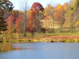
Winter in the mountains offers a unique and peaceful hiking experience. In Hot Springs, NC, the Appalachian landscape transforms into a serene escape filled with quiet beauty, crisp air, and unobstructed views.

Why Winter Is a Great Time to Hike

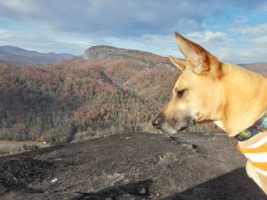
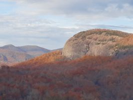
There’s nothing quite like a clear winter day in the mountains. With a thermos of hot chocolate in your pack and a chill in the air, the forest invites you to slow down and explore. The sky turns a brilliant blue, while the surrounding hills shift to deep shades of purple, mauve, and blue that are unique to this time of year.

Winter also opens up the forest. With leaves fallen and undergrowth gone, you can wander off-trail and take in the stillness of nature with little obstruction.

Mild Winter Weather and Wildlife Sightings

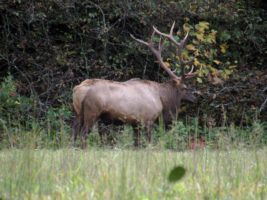
In Hot Springs, winter isn’t always cold. We often enjoy stretches of mild weather with temperatures in the 60s or even 70s—perfect for a spontaneous hike in short sleeves. During these hikes, it’s not uncommon to see wildlife such as:

  • White-tailed deer
  • Wild turkeys
  • Foxes and coyotes
  • Occasionally, elk

These encounters add a special touch to your winter adventure.

Hiking the Appalachian Trail in Winter

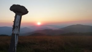
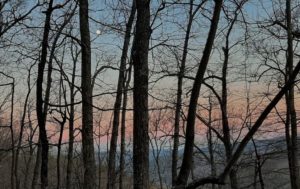
The Appalachian Trail (AT) runs along the ridge lines between North Carolina and Tennessee and is especially rewarding to hike in the winter. With fewer hikers on the trail, you can enjoy solitude and unobstructed mountain views.

One of the most memorable spots is where the local trail meets the AT—here, you can stand with one foot in each state. The views are expansive, and on the right day, you might even catch the moon rising as the sun sets.

Accessing the Appalachian Trail Near Hot Springs

The Appalachian Trail is easily accessible from multiple points near Hot Springs:

  • Highway 25/70 access point (just outside of Hot Springs toward Marshall)
  • Mill Ridge (reachable by gated road off 25/70)
  • Rich Mountain Trail (great for afternoon sun and scenic views)

To reach the 25/70 access:

  1. Drive through downtown Hot Springs heading toward Marshall.
  2. After passing under the highway underpass, turn left.
  3. Park at the gated road that crosses back over 25/70.
  4. If the gate is open, you may also drive up to Mill Ridge for higher elevation access.

Our favorite route is hiking north from this point up Rich Mountain, where the afternoon sun warms the trail and creates ideal winter hiking conditions.

Experience the Quiet Beauty of Winter Hiking in Hot Springs, NC

If you’re looking for solitude, mild weather, scenic views, and peaceful forest trails, winter is the perfect season to hike in the Hot Springs area. Whether you’re exploring the Appalachian Trail or wandering the open woods, winter hiking in the mountains is an unforgettable experience. Try our Moondance cabin for a private and serene getaway! 

Looking glass rock

Plutons in North Carolina Blue Ridge Mountains


Autumn at Looking glass rock

What Is a Pluton? Discover These Hidden Gems in the Blue Ridge Mountains

If you’re visiting the Blue Ridge Mountains and love scenic hikes, plutons are a must-see. Plutons in the North Carolina Blue Ridge Mountains are unique and fascinating. But what exactly is a pluton?

Plutons are massive, dome-shaped rock formations that rise above the forest—formed millions of years ago by volcanic activity. They’re like giant granite bubbles you can hike to for panoramic views of the surrounding wilderness. These natural wonders offer some of the best hiking trails and views in North Carolina.

One of our favorite day trips from Dancing Sun Cabins is a hike to John Rock, where you’ll get a breathtaking view of another pluton: Looking Glass Rock. On our last visit, we even saw two bald eagles fishing in the river below!

Plutons are magical places in our ancient hills.  They are like huge rock bubbles that you can climb up to get some of the most spectacular views in the Blue Ridge.  The above picture is a view from John’s Rock overlooking another pluton, called Looking Glass Rock.  On this hike, Tom and I got to witness 2 beautiful bald eagles flying below us and fishing on the river.

Plan a Pluton Day Trip from Dancing Sun Cabins

Plutons in North Carolina Blue Ridge Mountains are worth the trip!

The Best Views in the Blue Ridge are from the Top

Make sure you check the map at the kiosk at the trailhead so that you note the proper turns.  The trail is well marked with signs. The loop is explained in the link above.  It will take you by Cedar Rock Falls which is a beautiful spot to take a break, or a swim if it is warm enough.

Cedar Rock Falls

Looking Glass Rock: A  Vertical Challenge

Looking Glass Rock trail is more challenging, longer and steeper than the John Rock trail.  It is a spectacular climb for those who like to climb.  Therefore, this trail can be challenging and rocky in place.  Also, one must navigate some pretty rough and washed out places on the trail. However, the views are definitely worth the effort.

In addition, this is a coveted place for rock climbers.  Also, it is a rare nesting place for peregrine falcons. If you are lucky you will see them dive!


Why Visit Plutons During Your Stay?

Plutons are truly unique geological features that offer unforgettable hiking, photo ops, and wildlife viewing—all within a short drive of our cabins. Whether you’re an experienced hiker or just want a scenic adventure, these trails provide access to some of the best views in the Blue Ridge Mountains.

Book Your Stay Near the Best Hikes in Western North Carolina

At Dancing Sun Cabins, you’re just a scenic drive away from unforgettable day hikes like John Rock and Looking Glass Rock. After a day on the trail, return to your private mountain retreat—complete with cozy amenities, peaceful forest surroundings, and everything you need to relax and recharge.

The Elk are Returning to Max Patch

The AT crosses the top of Max Patch

Mornings on Max are nothing short of a miracle.  This morning we shuttled some of our guests up for a hike down to the cabins.  This is a wonderful 9-mile hike down from 4629 feet to about 2900 feet of elevation at the cabins.

Tom and I took the opportunity to walk over the “roof of our world” here in Spring Creek.   Max Patch is the highest point in our area and it never disappoints us.

On this fine morning. we were witness to a brand new baby elk being born.  When I captured her on camera, the distance and glare made it difficult to notice the baby.  I was very curious as to why she was alone, grazing in an open field.   The bulls are often alone, but most of the time the females are in herds.

We hope you enjoy this video which we entitled the Magic Morning on Max Patch.

For several years now, the National Park Service has been working to re-establish the elk in the Appalachian region.  This beautiful doe probably wandered over from the Cataloochee area of the Great Smoky Mountain National Park.   Or, perhaps she split off from the two herds that are pretty well established in the Harmon Den area just below Max Patch on the drive over to I-40.


Trout

Fishing

Fishing is really great in our area.  All of our streams are stocked with trout every Spring. Our creeks flow into Roaring Fork creek which flows into Meadow Fork creek , then Spring Creek into the French Broad river.   Here is a link to the Madison County Fishing Guide.

It is a fun day trip to visit the NC fish hatchery at the Pisgah Center for Wildlife Education.  The drive will take you throuh miles and miles of creeks and rivers and many, many waterfalls before you arrive at the hatchery at a place called John's Rock, which is one of our favorite hikes in the spring.

Brook Trout

You will need a NC Fishing License.  The pond at Max Patch is also stocked with trout every year.   This pond is located beyond the parking lot for hiking. To reach this pond, take Roaring Fork road to Meadow Fork road.  Turn right on Meadow Fork.  Proceed until you see the brown sign pointing you to Max Patch.  Turn right onto Little Creek Road.  It will turn to dirt.  Continue until you come to a T intersection.  Turn right at the T.  In about a mile you will see the parking lot for Max Patch on the right.  Just continue on the road and the pond is about 1/4 mile past the parking lot on the right.

Max Patch pond
Max Patch Pond is stocked for some wonderful still water fishing.

Pond at Max Patch Max Patch Pond