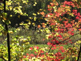
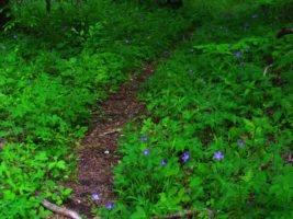
Summer is a special time of year in these mountains. The trees have shaded the forest floor, and now is the time of the tall wildflowers. It is a time of cicadas and fireflies, salamanders and peeper frogs. The forest is so alive.
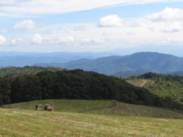
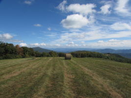
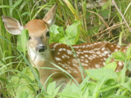
This morning, we decided to go up to visit Max Patch. We love to go in the early morning because the wild animals are out and about. This morning we got to see this sweet little baby. She was tucked safely in the tall weeds while her mother stood close by.
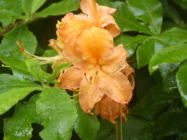
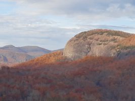
We made our journey up to Max Patch, marveling at the lushness of the forest. This time of year, the green is so intense. There are lots of trees and bushes blooming as well as wildflowers. We were quite surprised to find splashes of bright orange wild azaleas in the forests.

At Max Patch we were greeted by an empty parking lot. If you go in the morning, especially on a weekday, there are often fewer hikers.

Cloudy days are still beautful at the top of this mountain. I have never been disappointed in this place.
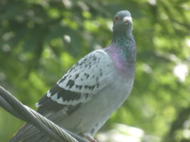
Tom and I have recently adopted some pigeons. They are “homing” pigeons, so we have dreams of bringing them up to the top of Max Patch, turning them loose and watching them fly home. Homing pigeons can fly for many, many miles and have been used to deliver messages and labwork.
Today is the summer solstice. We are celebrating and I love to sing. So, I made up this very silly song to sing as we climbed up the hill.
This is to the tune of the 12 Days of Christmas
On the first day of summertime my true love gave to me,
A pigeon in a pear tree.
On the seconday of summertime, my true love gave to me,
2 amaryllis and a pigeon in a pear tree.
On the third day of summertime, my true love gave to me,
3 little house wrens, 2 amaryllis and a pigeon in a pear tree.
On the fourth day of summertime my true love gave to me,
4 great blue heron, 3 little house wrens, 2 amaryllis and a pigeon in a pear tree.
On the fifth day of summertime my true love gave to me,
5 monarch butterflies, 4 great blue heron, 3 little house wren, 2 amaryllis and a pigeon in a pear tree.
On the sixth day of summertime my true love gave to me,
6 hens a laying, 5 monarch butterflies,4 great blue heron, 3 little house wren, 2 amaryllis and a pigeon in a pear tree.
On the seventh day of summertime my true love gave to me,
7 trout a swimming, 6 hens a laying, 5 monarch butterflies,4 great blue heron, 3 little house wren, 2 amaryllis and a pigeon in a pear tree.
On the eighth day of summertime my true love gave to me,
8 blue ghost fireflies, 7 trout a swimming, 6 hens a laying, 5 monarch butterflies,4 great blue heron, 3 little house wren, 2 amaryllis and a pigeon in a pear tree.
On the 9th day of summertime, my true love gave to me,
9 fairies dancing, 8 blue ghost fireflies, 7 trout a swimming, 6 hens a laying, 5 monarch butterflies,4 great blue heron, 3 little house wren, 2 amaryllis and a pigeon in a pear tree.
On the 10th day of summertime my true love gave to me,
10 frogs a leaping, 9 fairies dancing, 8 blue ghost fireflies, 7 trout a swimming, 6 hens a laying, 5 monarch butterflies,4 great blue heron, 3 little house wren, 2 amaryllis and a pigeon in a pear tree.
On the 11th day of summertime my true love gave to me,
11 Peepers peeping, 10 frogs a leaping, 9 fairies dancing,8 blue ghost fireflies, 7 trout a swimming, 6 hens a laying, 5 monarch butterflies,4 great blue heron, 3 little house wren, 2 amaryllis and a pigeon in a pear tree.
On the 12th day of summertime my true love gave to me,
12 grouse a drumming, 11 Peepers peeping, 10 frogs a leaping, 9 fairies dancing,8 blue ghost fireflies, 7 trout a swimming, 6 hens a laying, 5 monarch butterflies,4 great blue heron, 3 little house wren, 2 amaryllis and a pigeon in a pear tree.
Did you sing it all the way through?
Now for extra credit, how many gifts did my true love give to me?
Can you figure it out going forwards and backwards?
The answer is 364.
My true love is very good to me.
Happy Summertime Everyone!

 Winter is one of the most magical times to hike in the North Carolina mountains. With the leaves off the trees, the panoramic views stretch for miles, and the crisp mountain air makes every trail feel invigorating. Even in mid-winter, we often enjoy sunny days in the 60s and 70s — a true gift for outdoor lovers. We often have plenty of availability in the winter –
 Why Hike in Winter?
 Summer activities in Hot Springs NC are plentiful and fun!
 From mountain swimming holes to wildflower-filled hikes and river adventures,


 Dancing Sun Cabins is a great place support thru hikers or to even join someone on a hike along the Appalachian Trail.