Looking glass rock

Hanging out on a Pluton


Autumn at Looking glass rock

What it the world is a Pluton?

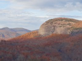
Plutons are magical places in our ancient hills.  They are like huge rock bubbles that you can climb up to get some of the most spectacular views in the Blue Ridge.  The above picture is a view from John’s Rock overlooking another pluton, called Looking Glass Rock.  On this hike, Tom and I got to witness 2 beautiful bald eagles flying below us and fishing on the river.

This is a day trip from our cabins.  We actually left about 10 am and stopped in Waynesville, NC to grab some lunch at our favorite burger joint, the Church Street Depot, then off to the Shining Rock Wilderness area on Hwy 276.  This takes you past the Cradle of  Forestry, Sliding Rock and Looking Glass Falls to name just a few places along the way. So, leave earlier if you want to visit these along the way, then you will have the whole day to enjoy this area.  There is much to see.  The trailhead to both the plutons is just past Looking Glass Falls on forest service road 475 C which will be on your right.  Looking Glass Rock trail is on the right and then John Rock is on the left at the Pisgah Wildlife Center and Fish Hatchery.

The Best Views in the Blue Ridge are from the Top

We love the plutons.  There are two that you can climb. Although it is a bit of a challenge and fairly steep in places,  both trails are worth the climb.   These pictures are from our hike along the loop trail at John’s Rock.

Hiking Suggestion

Make sure you check the map at the kiosk at the trailhead so that you note the proper turns.  The trail is well marked with signs. The loop is explained in the link above.  It will take you by Cedar Rock Falls which is a beautiful spot to take a break, or a swim if it is warm enough.

Cedar Rock Falls

Looking Glass Rock: A  Vertical Challenge

Looking Glass Rock trail is more challenging, longer and steeper than the John Rock trail.  It is a spectacular climb for those who like to climb.  Therefore, this trail can be challenging and rocky in place.  Also, one must navigate some pretty rough and washed out places on the trail. However, the views are definitely worth the effort.

In addition, this is a coveted place for rock climbers.  Also, it is a rare nesting place for peregrine falcons. If you are lucky you will see them dive.  They are spectacular.

Looking glass rock


Hiking is endless at Dancing Sun Cabins

Hiking Tips

Here are some things to think about when hiking in our woods.

Max Patch hiking is the best
Max Patch is one of our favorite places to hike
  • Take a map along. We have provided maps for you to carry with you that will help you find your way in our forest and connect to the Appalachian Trail.
  • We take a Garmen GPS unit with us, but we ALWAYS compare it to our maps. GPS can get you lost around here and it rarely gives you a good idea about how long a trail might be.
  • The blazes for the AT are white. When you see 2 blazes, that means to pay attention as there is another trail crossing the AT.
  • In the summer, the understory gets thick with stinging nettles, poison ivy and blackberry vines. Come prepared for this, or plan to hike on trails that are heavily traveled.
  • We do have snakes here. Most are not poisonous. Rattle snakes make a pretty loud sound. Copperheads are shy and prefer not to be bothered. These are the only two kinds of snakes that are poisonous here. It is best just to leave them alone. If you should experience a snake bite, just stay calm and get to help. Slow breathing and keeping your heart rate low is the best treatment.
  • Yellow jackets can be ferocious if disturbed. Please be aware that they live in holes in the ground. It is best not to poke holes in the ground. If they come after you….RUN!!!! Run away from their nest and try to get them off of you. They can sting more than once. Jewel weed takes the sting away.
  • It is good to carry 50 mg of Benadryl and 150 mg of Zantac with you just in case you experience and allergic reaction.

Here is a link to little video on helpful and harmful plants you may encounter along the way.

Midnight Hole at Big Creek, excellent swimming hole

Hiking Big Creek in the Great Smoky Mountain National Park

Tom and Rebecca Rating
Excellent Hiking

Midnight Hole at Big Creek, excellent swimming hole

Easy Trail
2 miles in and 2 miles out Excellent Swimming Hole…..Our Favorite!!!!
Excellent Jeep Trip (Call for directions)

One of our favorite places to go on a hot summer day is Big Creek. This creek offers great swimming holes and fishing holes. It has a nice gentle hike to 2 beautiful waterfalls.
We love to go here and cook a little lunch in the picnic area then go up to the falls for a dip.
The trail takes off from the picnic area. About a mile up if you look very carefully to the right you will see a trail that is not marked that goes up through some big rocks. About 100 ft up you will find an amazing and unique cave. It is work the climb.
However, if you are just enjoying the gentle hike, continue on up the main trail and look for a well traveled path to the right that leads to Midnight Hole. This is a glorious place to swim. Perhaps Rebecca’s favorite, as it offers a nice wide pool and the water is so clear you can see the fish swimming with you. Also, hearts appear here in the rocks as the sun changes position. It is really and amazing place.
Further up the trail is Mouse Creek Falls. This is also a beautiful waterfall and worth the extra half mile walk.
There are many different ways to get to Big Creek from Dancing Sun Cabins.
The Google map shows a way via Max Patch that includes dirt roads.
But, if you want to go the paved road way, see the directions below.

From Dancing Sun Cabins:Big Creek Waterfall

Take Roaring Fork to Meadow Fork and Turn Right
Go 3 miles to Caldwell mountain Road and Turn Left
Go to the end of Caldwell Mountain Road and turn Right on Hwy 209 S
Travel until you come to Furgeson’s store where Hwy 209 turns Left, but instead turn Right to go toward
I-40W. Turn Right on Fines Creek Road and Follow it as it bares left toward I-40.
Take I-40 W to exit 451 (Waterville Exit)
Turn left after crossing the Pigeon River and continue 2.3 miles and continue straight through the intersection past the ranger station and continue on to the picnic area. The trail head is at the picnic area. Big Creek favorites, can you see the heart?

Hiking Mount Pisgah

A great day trip to the high country is to drive to Mount Pisgah on the Blue Ridge Parkway.
It takes about an hour to get to the section of the Parkway then it is about 30 miles north to Mount Pisgah.
If you want to take a dip along the way you may want to stop at one of our favorite swimming holes, Skinny Dip Falls.

We have given you our “Tom and Rebecca Ratings”on the areas below:

Mount Pisgah Trail

Mt. Pisgah

T and R Rating:
Excellent Hiking

Moderate Difficulty
Excellent Views
Excellent Photography
Unique Tower at Top

Back on the Parkway you will head North to Mile post 408. Here you will find a trail to the top of Mount Pisgah which is 1.5 miles in length with about a 700 ft elevation gain. The gain is at the very end and is about .5 miles of very steep climb. It is well worth it.
We highly recommend enjoying a meal at the Pisgah Inn. The service is excellent, the food delicious and the view is exceptional.

Skinny Dip Falls:

T and R Rating:
Excellent Swimming
Easy to Moderate Hike
Short with some steep places
Approximately 1 mile in and 1 mile out

Located at Milepost 417 which is the Looking Glass Rock Overlook there is a trail head for Skinny Dip Falls. This Trail is across the road from the overlook to the north. The falls area has many private pools that are perfect for swimming.

Cradle of Forestry
T and R Rating
Excellent place to take Children or Elders
Best Wheel Chair Accessible Area we have ever visited!
Interactive Museum
Lots of Trails

Mile post 412 is known as Wagon Road Gap is where 276 crosses the road.
Take this exit and turn left to go to the Cradle of Forestry. It is well marked. You will be traveling toward Brevard.

Looking Glass Rock and Pisgah Wildlife Center

T and R Rating
Excellent Drives to photograph Looking Glass Rock
Wonderful Hiking Trails that are well marked with easy access

For a Jeep Trail Experience here is one way to drive to see the rock:
Further down Hwy 276 is a Forest Road 475B. This road is a pretty well maintained Forestry Road but it is gravel. You can take it down to 475 and head Left to the Fish Hatchery and Pisgah Wildlife Center.
Then you can travel further down 475 traveling the same direction and it rejoins Hwy 276 at Looking Glass Falls.

For a gentle Car Experience
Just continue on down Hwy 276 toward Brevard and you will see signs for the Fish Hatchery and Pisgah Wildlife Center

T and R Rating

Excellent Drive
Excellent Photography
Nice Swimming Experiences

Heading back toward the Parkway on Hwy 276 back toward Waynesville will take you back to the parkway. On the way you will pass Sliding Rock. This unique area is a fee area that allows you to slide down an amazing part of the creek if you are so inclined.