Hiking at Lemon Gap on the AT
Lemon Gap offers a nice spot to park your car along the AT in order to section hike. It is located between Max Patch and Walnut Mountain Shelter.
Lemon Gap Access Point on the Appalachian Trail is a bit remote. It is past Max Patch on a dirt road. Max Patch Road becomes Tenn. 107 after you cross the state line. The beauty of the remoteness makes it worth the drive.
From Max Patch to Lemon Gap 6.2 miles
The hike from Max Patch to Lemon Gap is mostly down hill and the walk is nice and gradual The hike to Max Patch is a little up hill , but surprisingly easy as the climb is gradual. There is a shelter between Lemon Gap and Max patch.
Lemon Gap to Bluff Mountain 3.7 miles
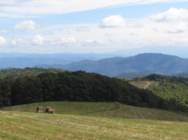
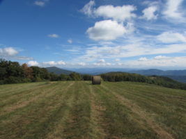
This is the easiest way to hike to Bluff Mountain whose elevation is just short of that of Max Patch. With a little over 1000 ft in elevation change, this makes for a good work out. You will come to Walnut Mountain Shelter (1.3 miles) before you get to Bluff Mountain. As you begin to climb up Bluff Mountain, you will see a camp site to the right and a trail leading to a big fields with a cross roads. Head out directly across from the camp site and follow the road up to a beautiful bald area known as Cat Pens.This is a beautiful bald that is similar to Max Patch only smaller. On a nice clear day, you can see Max Patch from this vantage point.
Bluff Mountain is where you will experience most of the elevation gain. You will hike up, up and up some more. But the view from the top is beautiful when the leaves are down. There is no bald up here but there are nice outcroppings.
Lemon Gap to Garenflo Gap 7.4 miles
If you continue on from the hike described above, you will descend from Bluff Mountain to Garenflo (AKA Gorenflo) Gap. This Gap offers a beautiful Rock that sits in the path of the rising and setting sun. This is a very nice hike and is a great work out as it takes you over Bluff Mountain.
Driving Directions: GPS location: N35° 49.30’ W082° 56.16’
From Dancing Sun Cabins
Go down Roaring Fork Road to Meadow Fork Road (State Road 1175). Turn right on Meadow fork and go a couple of miles until you see a brown sign directing you to Max Patch. Turn right on to Little Creek Road (State Road 1181). Follow Little Creek Road (1181) which will turn into a gravel road for 3.5 miles to a T intersection which is Max Patch Road (State Road 1182). Turn right onto Max Patch Road (gravel) and go for 1.6 miles to Max Patch parking and continue past Max Patch parking on a gravel road for 3.6 miles to the Lemon Gap parking access. This road becomes Tenn 107 when you cross the Tenn line.
Hiking the Trail:
North to Garenflo Gap (7.4 miles), go the direction of the white blaze on the post on the left side of the parking lot.
South to Max Patch (6.2 miles), go the direction of the white blaze on the tree on the right side of the parking lot.