There is an easy way and a harder way.
First the easy way.
Wear shoes that you can get in the water with. There is wading involved.
Drive to Hot Springs and turn left at Sara Jo’s gas station onto 25/70. Go about 1.5 miles to Upper Shut-in road and turn left. Go to the end of the road, it will turn to dirt and there may be a sign that says road closed. That is ok. Just go to the end where the forest service gate is usually closed. You can park there without blocking the gate.
Hike beyond the gate and in about 1/2 mile you will come to a T intersection. Turn left here and go until you come to the creek. There is a construction site there for a new bridge.
Make your to the other side of the creek and turn right to follow the creek down to the waterfall. You will come to a camping area. Look for a small trail at the end of the camping area that is unmarked, to make your way down to the fall. It is not a difficult trail.
T & R Rating
Excellent Hike! Excellent Swim!
Difficult
2000 ft total elevation
5 miles in and 5 miles out
10 miles total
Short areas of steep climbing, otherwise climb is gradual.
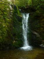
This favorite swim holes and hiking experiences is Wolf Creek Falls. This is one of the most beautiful waterfalls around and is accessible for a swim. We suggest you pack a lunch and head out with plenty of water. We often stash a bottle of water along the way for the return trip home.
This hike begins right behind our house and goes up to the forest roads and AT as the others do. It’s a tough hike, but it rewards you with a wonderful swimming experience is the clear waters of Wolf Creek.
So, head out behind the house and go up and through the fields. After about a mile you will come to a “T” intersection with a forest road. Turn left and go less than 1/4 mile and turn right onto an ATV trail. (If you get to the gate on the forest road you have gone to far)
Go up the ATV trail. This is a short steep climb (the steepest you will encounter on this trail)
In less than 1/4 mile you will reach the AT. This is Kale Gap. Go straight across on an old road. Continue on this road and you will come to a “Y” in less than 1/4 mile. Go to the right at this Y intersection and travel down. You will walk over a mile down and eventually you will come to a “T” intersection with another old road. DO NOT TURN LEFT here, but go right. In less than 1/2 mile the road will come to a subtle “Y”. You will go left here. There are huge rocks on both sides of the road, a culvert to your left and a sign on the tree that say” US Forest Land closed to all vehicles” Continue down the road here. You will begin to see orange, yellow and blue marks on the trees that were marked for a timber sale years ago. Continue down this old road. You are entering the area of the community of Wasp. In about a mile, you may notice a road to the Right. Do NOT take this road. Continue straight. You will cross a creek and bear to the right. Here you will begin to follow the creek . In less than 1/4 of a mile you can view a beautiful waterfall if you go over toward the creek. You should be able to hear it. There are, in fact, many places you can walk over to the edges of the rocks and view the creek as you walk down this section.
Not far after this waterfall, you will come to a road to the right. This leads into the old community of WASP.
(If you want to take this side trip, the road will cross a stream then you can begin looking for signs of old homesteads. Come back out this road to continue your hike to Wolf Creek falls)
To continue to Wolf Creek Falls
You will come upon an intersection with a road entering from the left. DO NOT TURN LEFT, stay on old road and continue walking down.
NOTE: Rattlesnake Gap Road sort of runs parallel to this old road you are on, but you do not want to get on this road too soon as it twists and turns and adds mileage.
Continue walking down the old road. Eventually you will come to a place where the old road almost joins the gravel road. Merge onto the gravel road here and turn right to go down. This is Rattlesnake Gap Road.
In less than 1/4 mile you will come to a sign that says Wolf Creek Falls 1/3 mile and points left.
Turn left here and cross Wolf Creek. Go to the camping are. To hike to the bottom of the falls, head out right from the camping area down by the creek. (NOT the ATV trail) To head to the top, go left of the camping area. Both are very short trails to the fall..not even 1/8 mile and provides privacy for a swim.
After your nice swim, rest, enjoy, replenish and prepare for your journey back.
