Summer Activities in Hot Springs, NC

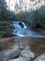
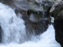
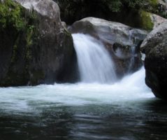
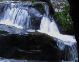
Discover the Best Summer Swimming Holes in Hot Springs, NC

Midnight HoleSummer activities in Hot Springs NC are plentiful and fun!

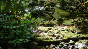
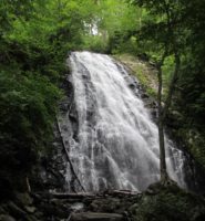
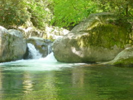
Looking to cool off this summer? Hot Springs and the surrounding areas offer plenty of refreshing swimming holes perfect for a dip in the creek. Explore scenic creeks and cascading waterfalls throughout the region. Want to venture a little farther? Click here to discover our favorite nearby swimming holes.

A summer swim in the mountains is the perfect way to relax, recharge, and beat the heat.

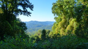
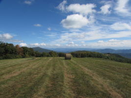
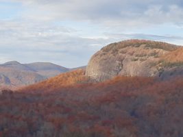
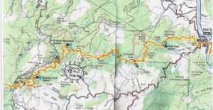
Summer Hiking in the Appalachian Mountains

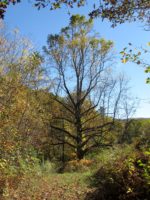
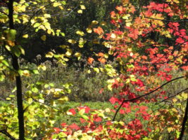
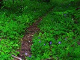
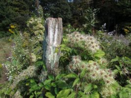
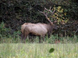
Summer transforms the Appalachian forests into a lush, vibrant landscape. Trails come alive with blooming wildflowers, towering greenery, and the rich scent of native plants. You’ll see mountain laurel, rhododendrons, flaming azaleas, and mountain magnolias in full bloom.

Hiking Tips:
Some less-traveled trails can become overgrown with stinging nettle, poison ivy, and briars. If a trail looks thick with vegetation, consider choosing a more frequently used path for a more comfortable hike. Summer activities like hiking really offer the best way to experience the bountiful nature of Western North Carolina.

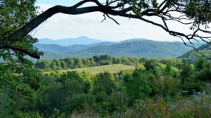
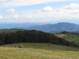
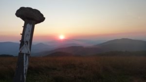
Popular Hiking Trails and Access Points:

  • Appalachian Trail (AT): Runs from Max Patch to Hot Springs
  • Easily Accessible Entry Points:
    • Max Patch
    • Lemon Gap
    • Gorenflo Gap
    • Hot Springs
    • Mill Ridge

Use this guide to choose your ideal hiking spot.

Enjoy the French Broad River in Hot Springs

Picture compliment of Hot Springs Rafting Company

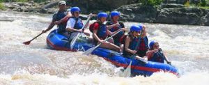
The French Broad River offers countless ways to enjoy the water during summer. Whether you’re into rafting, tubing, paddleboarding, or simply relaxing by the river, there’s something for everyone.

Easy River Access:
The river can be easily accessed from downtown Hot Springs. For rentals and guided adventures, visit the Hot Springs Rafting Company, which provides equipment for rafting and tubing.

Plan Your Perfect Summer Getaway in Hot Springs, NC

From mountain swimming holes to wildflower-filled hikes and river adventures, Hot Springs is the ideal destination for outdoor summer fun. Explore, relax, and reconnect with nature in one of the most beautiful regions of the Southern Appalachians. Summer activities in Hot Springs NC are a great way to spend those sunny and blue sky summer days!

Hiking the AT outside of Hot Springs, NC

Winter Hiking in Hot Springs, NC | Appalachian Trail Access & Scenic Views

Winter Hiking in Hot Springs, NC: Peaceful Trails and Stunning Views

“Thousands of tired, nerve-shaken, over-civilized people are beginning to find out that going to the mountains is going home; that wildness is a necessity.” — John Muir

Winter in the mountains offers a unique and peaceful hiking experience. In Hot Springs, NC, the Appalachian landscape transforms into a serene escape filled with quiet beauty, crisp air, and unobstructed views.

Why Winter Is a Great Time to Hike

There’s nothing quite like a clear winter day in the mountains. With a thermos of hot chocolate in your pack and a chill in the air, the forest invites you to slow down and explore. The sky turns a brilliant blue, while the surrounding hills shift to deep shades of purple, mauve, and blue that are unique to this time of year.

Winter also opens up the forest. With leaves fallen and undergrowth gone, you can wander off-trail and take in the stillness of nature with little obstruction.

Mild Winter Weather and Wildlife Sightings

In Hot Springs, winter isn’t always cold. We often enjoy stretches of mild weather with temperatures in the 60s or even 70s—perfect for a spontaneous hike in short sleeves. During these hikes, it’s not uncommon to see wildlife such as:

  • White-tailed deer
  • Wild turkeys
  • Foxes and coyotes
  • Occasionally, elk

These encounters add a special touch to your winter adventure.

Hiking the Appalachian Trail in Winter

The Appalachian Trail (AT) runs along the ridge lines between North Carolina and Tennessee and is especially rewarding to hike in the winter. With fewer hikers on the trail, you can enjoy solitude and unobstructed mountain views.

One of the most memorable spots is where the local trail meets the AT—here, you can stand with one foot in each state. The views are expansive, and on the right day, you might even catch the moon rising as the sun sets.

Accessing the Appalachian Trail Near Hot Springs

The Appalachian Trail is easily accessible from multiple points near Hot Springs:

  • Highway 25/70 access point (just outside of Hot Springs toward Marshall)
  • Mill Ridge (reachable by gated road off 25/70)
  • Rich Mountain Trail (great for afternoon sun and scenic views)

To reach the 25/70 access:

  1. Drive through downtown Hot Springs heading toward Marshall.
  2. After passing under the highway underpass, turn left.
  3. Park at the gated road that crosses back over 25/70.
  4. If the gate is open, you may also drive up to Mill Ridge for higher elevation access.

Our favorite route is hiking north from this point up Rich Mountain, where the afternoon sun warms the trail and creates ideal winter hiking conditions.

Experience the Quiet Beauty of Winter Hiking in Hot Springs, NC

If you’re looking for solitude, mild weather, scenic views, and peaceful forest trails, winter is the perfect season to hike in the Hot Springs area. Whether you’re exploring the Appalachian Trail or wandering the open woods, winter hiking in the mountains is an unforgettable experience. Try our Moondance cabin for a private and serene getaway! 

Looking glass rock

Plutons in North Carolina Blue Ridge Mountains


Autumn at Looking glass rock

What Is a Pluton? Discover These Hidden Gems in the Blue Ridge Mountains

If you’re visiting the Blue Ridge Mountains and love scenic hikes, plutons are a must-see. Plutons in the North Carolina Blue Ridge Mountains are unique and fascinating. But what exactly is a pluton?

Plutons are massive, dome-shaped rock formations that rise above the forest—formed millions of years ago by volcanic activity. They’re like giant granite bubbles you can hike to for panoramic views of the surrounding wilderness. These natural wonders offer some of the best hiking trails and views in North Carolina.

One of our favorite day trips from Dancing Sun Cabins is a hike to John Rock, where you’ll get a breathtaking view of another pluton: Looking Glass Rock. On our last visit, we even saw two bald eagles fishing in the river below!

Plutons are magical places in our ancient hills.  They are like huge rock bubbles that you can climb up to get some of the most spectacular views in the Blue Ridge.  The above picture is a view from John’s Rock overlooking another pluton, called Looking Glass Rock.  On this hike, Tom and I got to witness 2 beautiful bald eagles flying below us and fishing on the river.

Plan a Pluton Day Trip from Dancing Sun Cabins

Plutons in North Carolina Blue Ridge Mountains are worth the trip!

The Best Views in the Blue Ridge are from the Top

Make sure you check the map at the kiosk at the trailhead so that you note the proper turns.  The trail is well marked with signs. The loop is explained in the link above.  It will take you by Cedar Rock Falls which is a beautiful spot to take a break, or a swim if it is warm enough.

Cedar Rock Falls

Looking Glass Rock: A  Vertical Challenge

Looking Glass Rock trail is more challenging, longer and steeper than the John Rock trail.  It is a spectacular climb for those who like to climb.  Therefore, this trail can be challenging and rocky in place.  Also, one must navigate some pretty rough and washed out places on the trail. However, the views are definitely worth the effort.

In addition, this is a coveted place for rock climbers.  Also, it is a rare nesting place for peregrine falcons. If you are lucky you will see them dive!


Why Visit Plutons During Your Stay?

Plutons are truly unique geological features that offer unforgettable hiking, photo ops, and wildlife viewing—all within a short drive of our cabins. Whether you’re an experienced hiker or just want a scenic adventure, these trails provide access to some of the best views in the Blue Ridge Mountains.

Book Your Stay Near the Best Hikes in Western North Carolina

At Dancing Sun Cabins, you’re just a scenic drive away from unforgettable day hikes like John Rock and Looking Glass Rock. After a day on the trail, return to your private mountain retreat—complete with cozy amenities, peaceful forest surroundings, and everything you need to relax and recharge.

The Elk are Returning to Max Patch

The AT crosses the top of Max Patch

Mornings on Max are nothing short of a miracle.  This morning we shuttled some of our guests up for a hike down to the cabins.  This is a wonderful 9-mile hike down from 4629 feet to about 2900 feet of elevation at the cabins.

Tom and I took the opportunity to walk over the “roof of our world” here in Spring Creek.   Max Patch is the highest point in our area and it never disappoints us.

On this fine morning. we were witness to a brand new baby elk being born.  When I captured her on camera, the distance and glare made it difficult to notice the baby.  I was very curious as to why she was alone, grazing in an open field.   The bulls are often alone, but most of the time the females are in herds.

We hope you enjoy this video which we entitled the Magic Morning on Max Patch.

For several years now, the National Park Service has been working to re-establish the elk in the Appalachian region.  This beautiful doe probably wandered over from the Cataloochee area of the Great Smoky Mountain National Park.   Or, perhaps she split off from the two herds that are pretty well established in the Harmon Den area just below Max Patch on the drive over to I-40.


Heart in the waterfall at Midnight Hole in the GSMNP

Swimming at Big Creek in the Great Smoky Mountains National Park

Best  Swimming Hole Ever

Jumping in a creek in summer is one of the most refreshing experiences the Southern Appalachians have to offer. For swimming in summer, we love to have a nice dipping hole with places from which to jump.  One of our favorites is Big Creek.

This  is a pristine creek that rushes down the mountain in the GSMNP.  Our favorite spot on the creek is  Midnight Hole.  Just past this is Mouse Creek Falls which is also quite beautiful.   The hike up to this special spot is fairly short and easy.  It is about 1.5 miles and begins in the  parking lot of the Big Creek Campground  which is on the exit 451 on I-40 just over the border in Tennessee.

Directions

From our cabins there are a couple of ways you can travel to this magical place.  If you have a truck or 4 wheel drive you can go on the dirt roads up and over the mountain.  But, I do not suggest this route if you have a car without much clearance.  The road can get washed out and it can be pretty bumpy and challenging.  However, if you don’t mind going slow and taking your time, it’s a great way to see wildlife.  There is an elk herd along the way and they are pretty easy to spot.  We have also seen bear driving this way.  The other ways you can go are either through Waynesville for through Newport, Tenn.

To go the rugged way, take Roaring Fork and turn right on Meadowfork road.  Go about  1.5 miles and you will see a brown sign that says Max Patch.  Turn right onto Little Creek Road.  Go to where the pavement ends.  We advise you to turn right on Poplar Gap loop road as this is paved.  It’s very windy, so go slow.   When you come to a stop sight you will be back to Little Creek Road,  turn right.  Go until you come to a T intersection and turn left.  There are no signs on this road.  (Max Patch would be to the right).   After you turn left,  take the first right toward Harmon’s Den.   This road will take you to I-40.  Take  I-40 west to Exit 451 and go to the Big Creek Campground.   The trail head is across the road from the bath house.

Swimming Midnight Hole at Big Creek in the Great Smoky Mountain National Park

Can you see the heart?

Swimming Big Creek in the Great Smoky Mountain National Park

Here is a short video from swimming at Big Creek today.

Swimming can happen in many spots along the trail.

Elk herd at Harmon Den

Elk Herd

The elk hang out between the Harmon Den horse camp and the Harmon Den parking area.  There is a beaver pond they like to play in and some fields where they like to graze.   They are not hunted, so they are very calm and easy to observe.  But, they are very large, so do be careful and keep your distance.


Dancing Sun Cabins Hiking Map

Hiking and Hiker Support for the Appalachian Trail

Dancing Sun Cabin National Forest MapDancing Sun Cabins is a great place support thru hikers or to even join someone on a hike along the Appalachian Trail.

Our property sits at the base of Max Patch Mountain and Walnut Mountain. Our creeks drain both of these watersheds. It is a short drive to the Max Patch parking lot from our cabins or to the Gorenflo Gap parking lot. Both access points make it easy to access the trail by car. It is very easy to meet a hiker at Max Patch or Harmon’s Den and join the hike.

You can hike up to Lemon Gap or Walnut Mountain Shelter on a 1-2 hour hike from your cabin door. You can even hike up to Max Patch from our cabins with a little help with directions from Tom and Rebecca. The hike takes us a few hours to go up and back and is a little steep, but well worth it.

We love to do “trail magic” from time to time, so let us know if you are supporting a hiker and we may go up and feed them breakfast.

Hike From Your Cabin Door

From a “wander and ponder” stroll through the forest to steeper challenges that offer wonderful cardiac workouts, we have just the hike for you right out your front door.

Each cabin has a book with maps to help you find the perfect hike. Rebecca and Tom can also suggest hikes specific for the weather conditions and your needs.

There are many, many choices.

Hiking is spectacular any time of year.  Here is a video from our Autumn Hikes.

The Waterfall Trail:  Wander up the driveway and take right past the Appalachian Shack to the waterfall trail. We are so fortunate to have the National Forest for our backyard. Come and play. The waterfall offers a great opportunity to play in the creek on a hot summer’s day. Explore the cascades and waterfalls either in the creek or on the trail that winds in, out and around the forest.

The Labyrinth Trail:  There is only one spot on our 100 plus acres that you cannot hear our waterfall. This little Hollow tends to be silent, even on windy days, when the wind roars through the tree tops. This is the place we chose to build our Labyrinth. A Labyrinth is not a maze. It is a meditative walk with only one path through it. It is an ancient design. It is used for prayer and deep meditation. We welcome you to come and walk our Labyrinth in the woods. It is a short walk from your cabin door.

Loop to Cat Pen and T and R Bald: This is a 2-3 hour loop that we have created from our property that incorporates the Appalachian Trail. It is a delightful walk up to 2 bald areas that offer incredible views. Cat Pen is at the top and allows one a 360 degree view with an incredible view of Max Patch and Lemon Gap as well as Bluff Mountain.

Loop to Walnut Mountain: Another wonderful loop that incorporates the Appalachian Trail is our Walnut Mountain Loop. This takes 2-3 hours also and can be joined with the Loop to Cat Pen to make a nice full afternoon or day hike. This loop takes you to Walnut Mountain AT shelter. Here it is possible to go even further to Lemon Gap and then loop back to your cabin. The possibilities are endless as are the views.

Historical Wasp and Wolf Creek Falls: This is a challenging 10 mile hike that begins at the back of our house. It takes you through an old community that died out in the 1930’s. You walk across Kale Gap and down, down, down to the waterfall then back. This hike gives you a sense of what life must have been like to former generations. It is a full day hike and really for experience hikers. There are several opportunities to take the wrong path or road, so pay attention to the directions and always know how to come back.


Please join us in prayerful support of our Veterans as they “Walk off the War” by walking the entire Appalachian Trail.  We support Warrior Expeditions.

Walnut Mountain

Walnut mountain is the mountain we live on. You can access it right from your cabin door. It is full of Appalachian delights. There are many springs that run off this mountain and feed our waterfall. It is not unusual to see water just bubbling up from the ground. To us, nothing is more precious than this clear, fresh water.
We feel we are stewards of this land and we are blessed to live here. We love sharing this with others.

Our house sits 0.5 miles from the cabins. There is an old forest road that leads up behind our house and continues on to the to a place called Kale Gap. This is the route that families took for many years to connect the Roaring Fork community with the WASP community which was located on the other side.

On one side of this gap is Walnut mountain, on the other is Bluff mountain. The Appalachian Trail crosses here. There are many loops you can make with the AT and the forest road to give you some beautiful day hikes.

I have included some pictures of this mountain. To the South of Kale gap is Lemon Gap and Max Patch. To the North is Bluff Mountain and then on to Hot Springs. There is a nice bald to the north called Cat Pens.

The hiking possibilities are endless. Tom and I really enjoy just wandering through the woods here. It is a very special place.


Hiking from your cabin door Autumn Hiking

Walnut Mountain

Poke Berries

Walking up Walnut Mountain

Hiking is endless at Dancing Sun Cabins

Hiking Tips

Here are some things to think about when hiking in our woods.

Max Patch hiking is the best
Max Patch is one of our favorite places to hike
  • Take a map along. We have provided maps for you to carry with you that will help you find your way in our forest and connect to the Appalachian Trail.
  • We take a Garmen GPS unit with us, but we ALWAYS compare it to our maps. GPS can get you lost around here and it rarely gives you a good idea about how long a trail might be.
  • The blazes for the AT are white. When you see 2 blazes, that means to pay attention as there is another trail crossing the AT.
  • In the summer, the understory gets thick with stinging nettles, poison ivy and blackberry vines. Come prepared for this, or plan to hike on trails that are heavily traveled.
  • We do have snakes here. Most are not poisonous. Rattle snakes make a pretty loud sound. Copperheads are shy and prefer not to be bothered. These are the only two kinds of snakes that are poisonous here. It is best just to leave them alone. If you should experience a snake bite, just stay calm and get to help. Slow breathing and keeping your heart rate low is the best treatment.
  • Yellow jackets can be ferocious if disturbed. Please be aware that they live in holes in the ground. It is best not to poke holes in the ground. If they come after you….RUN!!!! Run away from their nest and try to get them off of you. They can sting more than once. Jewel weed takes the sting away.
  • It is good to carry 50 mg of Benadryl and 150 mg of Zantac with you just in case you experience and allergic reaction.

Here is a link to little video on helpful and harmful plants you may encounter along the way.

Lemon Gap Hiking on AT

Hiking at Lemon Gap on the AT

Lemon Gap offers a nice spot to park your car along the AT in order to section hike. It is located between Max Patch and Walnut Mountain Shelter.
Lemon Gap Access Point on the Appalachian Trail is a bit remote. It is past Max Patch on a dirt road. Max Patch Road becomes Tenn. 107 after you cross the state line. The beauty of the remoteness makes it worth the drive.

From Max Patch to Lemon Gap 6.2 miles
The hike from Max Patch to Lemon Gap is mostly down hill and the walk is nice and gradual The hike to Max Patch is a little up hill , but surprisingly easy as the climb is gradual. There is a shelter between Lemon Gap and Max patch.

Lemon Gap to Bluff Mountain 3.7 miles
This is the easiest way to hike to Bluff Mountain whose elevation is just short of that of Max Patch. With a little over 1000 ft in elevation change, this makes for a good work out. You will come to Walnut Mountain Shelter (1.3 miles) before you get to Bluff Mountain. As you begin to climb up Bluff Mountain, you will see a camp site to the right and a trail leading to a big fields with a cross roads. Head out directly across from the camp site and follow the road up to a beautiful bald area known as Cat Pens.This is a beautiful bald that is similar to Max Patch only smaller. On a nice clear day, you can see Max Patch from this vantage point.
Bluff Mountain is where you will experience most of the elevation gain. You will hike up, up and up some more. But the view from the top is beautiful when the leaves are down. There is no bald up here but there are nice outcroppings.

Lemon Gap to Garenflo Gap 7.4 miles

If you continue on from the hike described above, you will descend from Bluff Mountain to Garenflo (AKA Gorenflo) Gap. This Gap offers a beautiful Rock that sits in the path of the rising and setting sun. This is a very nice hike and is a great work out as it takes you over Bluff Mountain.

Driving Directions: GPS location: N35° 49.30’ W082° 56.16’

From Dancing Sun Cabins
Go down Roaring Fork Road to Meadow Fork Road (State Road 1175). Turn right on Meadow fork and go a couple of miles until you see a brown sign directing you to Max Patch. Turn right on to Little Creek Road (State Road 1181). Follow Little Creek Road (1181) which will turn into a gravel road for 3.5 miles to a T intersection which is Max Patch Road (State Road 1182). Turn right onto Max Patch Road (gravel) and go for 1.6 miles to Max Patch parking and continue past Max Patch parking on a gravel road for 3.6 miles to the Lemon Gap parking access. This road becomes Tenn 107 when you cross the Tenn line.

Hiking the Trail:

North to Garenflo Gap (7.4 miles), go the direction of the white blaze on the post on the left side of the parking lot.
South to Max Patch (6.2 miles), go the direction of the white blaze on the tree on the right side of the parking lot.

Hike to Lemon Gap from Max Patch

Fields at Max Patch after they mow

Appalachian Trail blazes are white

Light in the Pisgah National Forest

Rankin Bottoms: A great place for bird watching

One of our favorite places to visit in the winter is Rankin Bottoms.

This unique wildlife area is located where the Nolichucky and French Broad rivers meet and enter Douglas Lake. This is a flood plane area.

The water level is managed by the TVA. The water level is dropped very low in the winter leaving mud flats and watering holes that are perfect areas for birds to gather. This high altitude swamp has unusual features such as Osage orange trees, Cyprus trees, and Honey Locusts.

This is often a warm sunny spot in the winter and a great place to see large birds such as Egrets and Herons. Geese,Sandpipers, Gulls and many other birds find this the perfect spot to feed. Check out what the Tennessee Ornithological Society has to say about this place. It’s incredible!

The landscape has unique plant life that create surreal colors and scenery. We find it a great place to wander.

​To reach Rankin Bottoms, you must travel to Newport, Tennessee. We advise going to Hot Springs and following 25/70. The road is not really closed even though the bridge is out. You can take Fugate Road, just go slow as the locals do. When you get to the end of Fugate, turn right on Hwy 107 and cross the bridge. Turn left toward Newport on 25/70.
Go through downtown Newport and bare right on Industrial Road. Stay on Industrial Road about 5 miles you will have to turn left to remain on Industrial road, the go another 5 miles until you reach Rankin Hill Road. There will be a Wildlife refuge sign here. The road follows the railroad tracks and is a little rough in places, though you do not have to have 4 wheel drive unless it is muddy.